Newsday of 1.8.2013 published a summary article titled "A Tally of Storm's Wrath," reporting numbers that the newspaper had received from the Federal Emergency Management Agency. The only number that specifically mentioned Seaford was the Maximum Water Height in Seaford of 8.36 feet. According to the text of the article, the figure was derived from tide gauges in the bays and observations along the coast. A friend told me that FEMA representatives were measuring high water marks on buildings a day or two after the storm.
----
Newsday offered FEMA's inundation map at http://newsday.com/sandy but I could not access it. Hopefully, the map will become available on FEMA's website, which at the moment offers the 2009 flood prediction map.
Showing posts with label Sandy. Show all posts
Showing posts with label Sandy. Show all posts
Wednesday, January 9, 2013
Wednesday, December 5, 2012
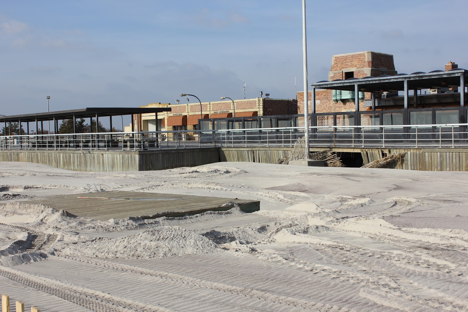
Jones Beach, a month after Sandy
In early December, a friend parked at Jones Beach, Field 6, and hiked west in the sand. Below, I will post some of his photos in westward order and let the readers' knowledge of the landscape make up for my lack of captions. Any photo may be enlarged by clicking on it. Some photos appear to have been taken with a strong zoom or telescopic lens.
 The above photo is taken at the beginning of the boardwalk at Field 6.


 Note the sea grass caught by the balustrade.


 Looking towards the playground and West Bathhouse.


Tuesday, November 27, 2012
A letter from the Historical Society
Seaford Historical Society to Aid "Sandy"
Victims
In the wake of the recent storms, hundreds of Seaford Harbor residents were driven from their homes; many are as yet unable to return.
While many precious possessions were lost or damaged, it's materials to help make their homes reasonably habitable that are among their immediate needs.
The Seaford Historical Society plans to lend a considerable hand by raising funds to purchase gift cards for home-damaged Seafordites.
Welcome to "Aunt Barbara's Tupperware
Party!"
Aunt Barbara's parties always combine "laugh-til-it-hurts" hilarity with a most informative presentation of the latest products from Tupperware.
Since just about everyone could use a Tupperware product now and then (i.e., many Seaford and Wantagh fisherman use their containers to store bait), do plan to attend.
Aunt Barbara's Tupperware Party:
Fundraiser produced by Seaford Historical Society
Wednesday, December 5th, 7:00 PM
Admission fee - $ 15.00
Raffles, 50/50
Refreshments will be served
For details/order tickets thru
PayPal: visit www.seafordhistoricalsociety.org and click the Events tab.
Or contact us at seafordhistoric@optonline.net
Or call Carla at 826-7642
If you are unable to attend but want to help
please consider sending a donation to Seaford Historical Society, PO Box 1254,
Seaford 11783 (put “Sandy” on memo line)
Not appropriate for children
Sunday, November 25, 2012
On the Bay, part two, after Sandy
This afternoon, 11.25.2012, Newsday's website displayed an article that will probably be in tomorrow's print edition. The title is "Few bay houses left standing after Sandy."
----
A small section of the article reads:
Baymen first built houses out here generations ago, not as primary residences but as bases of operation to harvest salt hay and shellfish. Their descendants battled the insults of nature, municipal ill will and even a spate of arson to keep them. Some were still used by working baymen; some were weekend retreats for families who no longer made a living on the water.
But superstorm Sandy did worse in a matter of hours than had been done in the past century, destroying at least 18 houses, seriously damaging two and leaving 10 intact, according to folklorist Nancy Solomon, who has written about the houses and surveyed them last week.
----
For Nancy Solomon's presentation to the Seaford Historical Society a year ago, please click here.
----
A small section of the article reads:
Baymen first built houses out here generations ago, not as primary residences but as bases of operation to harvest salt hay and shellfish. Their descendants battled the insults of nature, municipal ill will and even a spate of arson to keep them. Some were still used by working baymen; some were weekend retreats for families who no longer made a living on the water.
But superstorm Sandy did worse in a matter of hours than had been done in the past century, destroying at least 18 houses, seriously damaging two and leaving 10 intact, according to folklorist Nancy Solomon, who has written about the houses and surveyed them last week.
----
For Nancy Solomon's presentation to the Seaford Historical Society a year ago, please click here.
Wednesday, November 7, 2012
Sandy and Seaford creeks
Hurricane Sandy pummeled the south shore of Long Island with wind, tide, and rain. Damage extended across the island and hurt many people in their lives, with deaths and damaged homes. In this post, I choose to look at a more limited topic, how the three north-south creeks in Seaford rose with the run-off, tide, and wind. I wish I had more facts to present, but I did not go out exploring during the storm. This narrative will probably contain errors. I appreciate corrections and further explanations.
----
Cedar Creek flows between Fir and Larch Streets. I am quite certain it forms the western limit of the Seaford School District. It emerges south of Merrick Road in Cedar Creek Park and flows into East Bay. The dip in Merrick Road is quite obvious here, and on Tuesday it seemed to have pooled atop Merrick Road. Some residual debris was noticeable on Merrick Road near Willow Street, but I don't know whether it came from Cedar Creek's backup or some other source.
----
It seems that a section of Seamans Creek was channeled by the construction of NY 135, as a 1903 map shows it beginning at a pond north of DeMott Avenue, almost at the water company property. Seaman's Creek runs along the west side of NY 134, under the railroad and Sunrise Highway, reappearing northwest of Brook Lane's cul-de-sac. The creek goes under Alan Path, lingers west and north of Natalie Boulevard (where the 1903 map shows a larger pond), and passes under Woodward Avenue. Some hours before the storm, the water had already risen to the height of adjacent lawns. Overnight and later, I am told it closed Waverly Avenue. As far as I can determine, this closure on Waverly Avenue, just east of the NY 135 bridge, was the northernmost flooded road in Seaford, about 5.2 miles from the Atlantic Ocean. That is, the wind-driven high tide had caused the level of Seamans Creek to cover Waverly Avenue there.
----
Seaford Creek, the longest of Seaford's creeks, forms the border between the Town of Hempstead and that of Oyster Bay, a border which dates back to the mid-1600's and the era of Tackapausha. It seems to form about Jerusalem Avenue and the north end of Tackapausha Preserve, flowing through the preserve to the lake at Merrick Road and then with waterside homes south of Merrick Road. Early Monday afternoon, it overflowed two eastbound lanes of Merrick east of Townsend Court. As the "puddle" grew, police forbade traffic. I think I can safely say that the puddle increased from south to north, showing that this was the effect of tide, not yet a heavy run-off from the lake.
----
A friend pointed out that the height of a wind-driven tidal surge rises in narrow confines. That may explain why the canals of south Seaford rose to cover streets and to damage basements and ground floors of homes.
----
Cedar Creek flows between Fir and Larch Streets. I am quite certain it forms the western limit of the Seaford School District. It emerges south of Merrick Road in Cedar Creek Park and flows into East Bay. The dip in Merrick Road is quite obvious here, and on Tuesday it seemed to have pooled atop Merrick Road. Some residual debris was noticeable on Merrick Road near Willow Street, but I don't know whether it came from Cedar Creek's backup or some other source.
----
It seems that a section of Seamans Creek was channeled by the construction of NY 135, as a 1903 map shows it beginning at a pond north of DeMott Avenue, almost at the water company property. Seaman's Creek runs along the west side of NY 134, under the railroad and Sunrise Highway, reappearing northwest of Brook Lane's cul-de-sac. The creek goes under Alan Path, lingers west and north of Natalie Boulevard (where the 1903 map shows a larger pond), and passes under Woodward Avenue. Some hours before the storm, the water had already risen to the height of adjacent lawns. Overnight and later, I am told it closed Waverly Avenue. As far as I can determine, this closure on Waverly Avenue, just east of the NY 135 bridge, was the northernmost flooded road in Seaford, about 5.2 miles from the Atlantic Ocean. That is, the wind-driven high tide had caused the level of Seamans Creek to cover Waverly Avenue there.
----
Seaford Creek, the longest of Seaford's creeks, forms the border between the Town of Hempstead and that of Oyster Bay, a border which dates back to the mid-1600's and the era of Tackapausha. It seems to form about Jerusalem Avenue and the north end of Tackapausha Preserve, flowing through the preserve to the lake at Merrick Road and then with waterside homes south of Merrick Road. Early Monday afternoon, it overflowed two eastbound lanes of Merrick east of Townsend Court. As the "puddle" grew, police forbade traffic. I think I can safely say that the puddle increased from south to north, showing that this was the effect of tide, not yet a heavy run-off from the lake.
----
A friend pointed out that the height of a wind-driven tidal surge rises in narrow confines. That may explain why the canals of south Seaford rose to cover streets and to damage basements and ground floors of homes.
Subscribe to:
Posts (Atom)